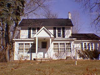
21 Clarkston Rd.

Previous research done in 1979 listed the likely construction date for the original section of this house as 1855, however the 1872 Map of the Village has no building footprint on this site then. Tax records listed a substantially increased assessed value for the property in 1889, owner A. J. Crosby indicating either the construction of a building or a major addition/alteration to an existing building. The fishscale shingles in the gable ends of the two story section of the house probably date from that time since they were an important element of the Queen Anne style houses built at the end of the 19th century. The house has seen at least four substantial changes since it was constructed. According to the 1979 research a bedroom was added in 1905, a bathroom in 1916 and the front porch in 1917. The kitchen was rebuilt in 1962. The first story and east facades were remodeled in the 1990s when windows were replaced and the front entrance gable roof and supporting columns were added. Historically the home was owned in 1917 by A. B. Wompole, one of the Clarkston residents who registered the King-Wompole Plat, an addition to the existing plats of the Village of Clarkston. Mr. Wompole developed the area which surrounds Womplole Dr.
- A piece in the Northeast 1/4 of Section 20 in Independence Township, not a part of Nelson W. Clark's Original Plat of the Village. >LI< Lot 57 of the Supervisor's Plat No. 1.
- Note: All the properties currently located in the Historic District were originally part of a tract registered by Butler Holcomb with the federal government on October 22, 1831. Thus, abstracts for these properties, when they exist, show the original transfer to be from the United States to Butler Holcomb and may also include references to then President Andrew Jackson.
- 1844 Ebenezer Clark, the west 1/2 of the Northeast 1/4 of Section 20, assessed value $200. Jacob Walter, 1 acre in the corner of the southwest 1/4 of the Northeast 1/4 of Section 20, assessed value 420.
- 1847 Joseph Chapman the west 1/2 of the Northeast 1/4 of Section 20, assessed value $150.
- 1848 Joseph Chapman, the west 1/2 of the Northeast 1/4, assessed value $169.
- 1872 Map of the Village has no building footprint, owner R. E. Follett. Tax record info: R. E. Follett, 12 acres, a piece of land bound south by the land of V.C. Vliet, west by the highway, north by J. Carran, east by his own land, assessed value $400.
- 1873 as above.
- 1874 as above.
- 1876 S. & W. Burgess, as above.
- 1877 R. E. Follett, as above.
- 1878 as above.
- 1881 A. J. Crosby, north by Fred King, west by his own, V. C. Vliet, Carran & Robertson, south by the highway, east by George Sibley, assessed value $400. Also, a piece north by Mrs. James Carran, west by the Street, south by V. C. Vliet, east by his own land, assessed value $1000.
- 1883 as above.
- 1884 as above.
- 1885 as above.
- 1886 A.J. Crosby, first piece listed above, assessed value $300. Second piece, assessed value $700.
- 1888 as above.
- 1889 A.J. Crosby, a piece of land bound north by "Cristie" Carran & Frank King, east by the land of George Sibley & the highway, south by the highway & the land of "Ranson" Vliet, west by "Cristie" Carran, "Ranson" Vliet, L. C. Robinson & the Street, assessed value $1400.
- 1891 as above.
- 1892 as above.
- 1893 as above, assessed value $1150.
- 1894 as above, assessed value.
- 1895 as above, assessed value $1100.
- 1898 Mrs. Crosby, assessed value $1100.
- 1899 A. J. Crosby, estate, a piece north by tyhe land of C. Carran, east by George Stevens, south by the land of V. C. Vliet, west by the Street, assessed value $700. Mrs. A. J. Crosby, north & east by the land of George Stevens, south by the Highway, west by V. C. Vliet & C. Robinson, assessed value $2100.
- >1900 A. J. Crosby, estate, as above, assessed value $900. Mrs. A. J. Crosby, as above, assessed value $400.
- 1902 A. J. Crosby, estate, as above. Mrs. "M. J." Crosby, as above, assessed value $500.
- 1904 Edwin Jefferson, north & east by the land of George Stevens, south by the highway, west by Vliet & C. Robinson, assessed value $700.
- 1905 Edwin Jefferson, as above, assessed value $800.
- 1906 E. Jefferson, Estate, as above, assessed value $1000.
- 1907 as above.
- 1908 as above.
- 1909 John Knox, as above, assessed value $800.
- 1910 John Knox, as above, assessed value $1600.
- 1914 John Knox, north & east by J.L. Morrison, south by Jefferson Street, west by Mrs. L. E. Robinson, assessed value $700. (J. L. Morrison, north by D. Miller, east by the Corp. line, south by Jefferson Street, west by J. Knox, Robert Kirchener & Oliver La Mountain, assessed value $900.
- 1915 John Knox, asssessed value $800. J.L. Morrison, assessed value $400.
- 1917 A. B. Wompole, north by Denby, east by the Corp. line, south by the Street, west by Robinson, "Kircherner" & LaMountain, assessed value $1200.


