12 South Main St.

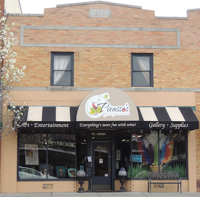
Local businessmen Teggerdine, King, Landi, Hubble and Hopkins had this building, originally all yellow brick, constructed to replace four wooden structures which burned in 1927.
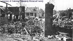
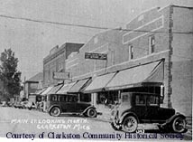
This storefront is a part of the "Brick Block" which was constructed in 1928 to replace the four wooden buildings which burned in 1927, photo left. A photo just prior to the fire shows Frank C. Dunston, meat, fish, groceries at 12 South Main. The store in the wooden building in 1904 was occupied by the meat market of R. W. Kirchner, who for a year was in business with Adolph Meyer, then Burt Crosby & David Teggerdine. (Tax records listed Crosby & Teggerdine for the property 1920-1928). More history regarding the wooden building is related below. The new yellow brick building originally housed four separate storefronts on the first floor. The store in this section of the building in 1932 was Waterbury's Home Market, J. L. Waterbury, proprietor. In 1937, Earl Terry who worked for Frank Dunston, then Waterbury, began to buy an interest in the market which he renamed Terry's Market. Terry's did business here until 1967. (However, according to a Clarkston News item 2/2/1950 Taylor's 5 & 10 moved in to part of the space in 1950. Prior to that time they occupied the space of 16 South Main which was originally that of Landi and Ronk.) In the 1970s, the Village Sewing Basket occupied the first floor of this space. Historically the wooden building which stood on this part of Lot 3, (see the building footprint on the 1872 Map of the Village) was a part of Horatio Foster and William S. Blake's property as early as 1843. Both men were among Clarkston's earliest businessmen. Horatio Foster is said to have been the first harness maker in the Village with a shop on Main St. His will of 1861, found in the abstract for 8 East Washington, listed a harness and millinery shop and a dwelling on S. Main Street. This property now 12 South Main was probably the site of the dwelling house. William S. Blake, the other owner of part of this Block, is said to have been the first shoemaker in the Village. In 1876 Edward A. Urch, was listed for both parts of the site previously owned by Foster and Blake. Urch had a dry goods and drug store on the north part of the site while Ash & Beardslee had a business to the south. The history of this site and all of the property south of Washington street seems a bit confused when the items in area newspapers areas compared with the tax records. An item in The Pontiac Post of 4/06/1900 notes "Fred Vliet is going to open a new meat market. Dan Addis will erect if for him." Frank Beardslee was to do the construction. Addis owned the piece at the southeast corner of East Washington and South Main Street but not this piece, while Fred Vliet was listed in the tax rolls for part of this property in 1914 &1915. The latter, most southern piece, changed hands several times in the next twenty years. Robert Reid, the Coon brothers and John T. P. Smith among others were listed for the southern part of this site. An advertisement in the Pontiac Post of 1/09/1902 for the business of G. F. Coon read, " G. F. Coon Carries the Finest Line of Hardware, Stoves, Ranges, Tinware, Bicycles, Hammocks and Pumps of any General Store in Oakland Co. First Class Tinner in Connection. Paper rags taken in exchange for goods. Clarkston, Michigan." A 6/12/1902 issue noted "William Petty has engaged the tinshop of G. F.Coon and son and is ready to do all business relating to the trade." Trustees for the estate of G. F. Coon "closed out the sale of goods" in 1905 according to an item in the 3/16/1905 issue of the Oakland County Post. In 1902 Adolph Meyers opened a meat market on the site of 12 South Main. Meyers and Robert Kirchner were partners for a time. The partners also engaged in the "poultry trade". According to an item in the Oakland County Post, 12/22 1904, the Meyers "will move to Detroit and summer in the house on West Washington Street" in Clarkston. Robert Kirchner took over the business followed by S. and F. Vliet in 1913, Ed. Weiland and G. B. Cross in 1919, then Crosby and Teggerdine in 1920. Tax records of the early 1900s seem to indicate buildings behind these storefronts between here and E. Church St., probably warehouses and/or barns. (For example 1915 Hill and Walter north by Vliet, and east & south by Walter, west by Urch.)
- Middle part of Lot 3 Block 1 of Nelson W. Clark's Original Plat of the Village in the Southeast 1/4 of Section 20 in Independence Township
- Lot 53, (21' x 169'), of the Assessor's Plat.
- 1831 United States to Butler Holcomb.
- 1833 Butler Holcomb & wife, Mary, To Roswell/Roosevelt Holcomb, the west 1/2 of the Southeast 1/4 of Section 20.
- 1833 Butler Holcomb & wife, Mary, To Roswell/Roosevelt Holcomb, and wife, Elvine Holcomb, and Daniel B. Holcomb and wife, Alimira, to Jeremiah Clark III, the south part of the west 1/2 of the Southeast 1/4 of Section 20.
- 1839 Jeremiah Clark III to Nelson Washington Clark, the undivided 1/2 of the west 1/2 of the Southeast 1/4 of Section 20 commencing.......
- 1842 Jeremiah Clark III & wife, Polly, to Nelson W. Clark, the south part of the west 1/2 of the Southeast 1/4 of Section 20. Also other land.
- 1842 Jeremiah Clark III & Nelson W. Clark to Village of Clarkston (Original plat of the Village).
- 1843 Horatio Foster and Wm S. Blake, Lot 3 Block 1.
- 1855 Wm. S. Blake, the west 1/2 of the south 1/2 of Lot 3 Block 1, assessed value $100. H. Foster, the north 1/2 of Lot 3, assessed value $330.
- 1856 Wm. S. Blake, the west 1/2 of the south 1/2 of Lot 3 Block 1, assessed value $200. H. Foster, the north 1/2 of Lot 3, assessed value $330.
- 1857 Wm. S. Blake, the west 1/2 of the south 1/2 of Lot 3 Block 1, assessed value $400. H. Foster, the north 1/2 of Lot 3 Block 1, assessed value $330.
- 1858 H. Foster, the north 1/2 of the south 1/2 of Lot 3 Block 1, assessed value $400.
- 1861 Foster died. See the property history for 4 South Main for the details of the will.
- 1872 Map of the Village has a building footprint on a part of Lot 3. Tax info: J. G. Owen 20' off the south side of Lot 3 Block 1, assessed value $100
- 1876 E. A. Urch, Lot 3 Block 1.
- 1880 E. A. Urch, the north 1/2 of the south 1/2 of Lot 3 Block 1, assessed value $800.
- 1881 Ash & Beardslee, the west 1/2 of the south 1/2 of Lot 3 Block 1, assessed value $400. Robert Reid, 20' off the south side of Lot 3 Block 1, assessed value $400.
- 1884 Robert Reid, as above.
- 1886 Coon Brothers, the west 1/2 of the south 1/2 of Lot 3 Block 1, assessed value $500. Robert Reid, as above.
- 1898 John T. P. Smith, the west 1/2 of the south 1/2 of Lot 3 Block 1, assessed value $440.
- 1900 as above, assessed value $500.
- 1902 Henry Spicer/Spycer, 20' off the south side of Lot 3 Block 1, assessed value $700. Alfred Carran, a piece commencing 3' north of the northeast corner of Lot 3 Block 1, then west 80', north 20' 6", east 80' 5", assessed value $100. George F. Coon, (a piece that was Alfred Carran's) a piece commencing 3' north of the northeast corner of Lot 3 Block 1 thence west 80', thence north 20' 6", thence east 80', thence south to the place of beginning, assessed value $100.
- 1911 Henry Spicer, assessed value $700.
- 1914 S. & F. Vliet, the south 1/2 of Lot 3, assessed value $100. Ed. A. Urch, the south 22' of the west 1/2 Lot 3 Block 1, assessed value $750.
- 1915 Fred Vliet, the south 1/2 of Lot 3 Block 1, assessed value $100.
- 1916 Urch, same as 1914, north by Vliet, east by Hill & Walter, south by Bower Est., west by Main, assessed value $800.
- 1920 E. Urch Est., north by Vliet, east by F. Howland, south by Bower Est., west by Main, assessed value $800. Weiland and Crosby, south 1/2 of Lot 3, assessed value $1200.
- 1920 Crosby and Teggerdine, south 1/2 of Lot 3, assessed value $2200.
- 1925 Teggerdine, south 1/2 of Lot 3.
- 1927 Fire
- 1928 Teggerdine and King, part of Lot 3 commencing on the west line of Lot 3, 21 1/2' south of the northwest corner, then south 26,5', then east 85', north 5.5', east 80', assessed value $4000.
- 1935 Waterbury.
- 1945 Earl & Marian Terry. Terry's Market.


