23 South Main St.

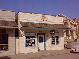
This "fire proof" building was built in 1925 and first served as the Post Office. The Post Office moved 20 years later to the building to the north, 21 South Main Street. The pent roof which was an addtion to the original building was removed in June of 1999.
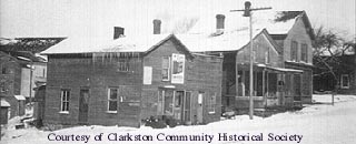
This brick building was originally known as the Teggerdine-King building. The two men took out a building permit in Dec.,1924 for a "fire proof" building which was first used for the Post Office, Floyd Andrews, Postmaster. In 1936 Mrs. Elizabeth Ronk became Postmistress. The Post Office remained here another 20 years until it moved to 21 S. Main. Since then the building has served several owners and uses. In 1956 it was the site of the Clarkston Bakery followed by the Clarkston Shoe Service in 1960. The office of King Insurance Agency, formerly located in a corner of the Clarkston State Bank moved here by 1966. An ice cream parlor opened here in the 1970s. In recent years Patricia's Beauty Salon then Clarkston Hair Design have occupied the building. Architecturally, the building constructed of brick is reminiscent of the wooden false-front buildings built across the country during the early development of towns. The front facade of the such buildings rose above the actual roof to give the structure more importance. The pent roof on the street facade capping the windows seen in the photo above was not original to the structure and was removed in June of 1999. Historically, until 1869 all of this lot was a part of the Clarkston mill property of Hurst/Hirst & Stiff. (Hirst bought the mill and attendant property from Jeremiah III and Nelson Clark.) Physician, M. A. Root had the north piece of this property by 1875, while P. J. Abbey owned the southerly piece. There were at least 4 wooden store fronts on the property of 23, 25 and 27 South Main Street in the past. The 1872 map of the Village shows the footprints of only two buildings at that time, those belonging to Nelson Abbey & J. W. Howe. Nelson Abbey was a doctor and Clarkston Postmaster at the time.
- North 1\2 Lot 3 Block 25 of Nelson W. Clark's Original Plat of the Village in the Southwest 1/4 of Section 20 in Independence Township.
- Lot 76 of the Assessor' Plat.
- 1847 Jeremiah III & Nelson W. Clark, Mill property, assessed value $2000.
- 1849 Nelson W. Clark & Abraham Houghtelin, Lots 2 & 3 Block 25, last description known as Mill property, assessed value $1900.
- 1869 Hurst/Hirst & Stiff, Lots 2 &3 "Block 5, " except 15' off the north side of Lot 2 and 20' on Main running back to L. Bingham, assessed value $300.
- 1870 N. Abbey, assessed value $200.
- 1872 Nelson Abbey, east by Main, south by J. W. Howe, west by Bingham, north by Hirst & Stiff, assessed value $200.
- 1875 P. J. Abbey, east by Main, south by J. W. Howe, west by Bingham, north by M.A. Root, assessed value $200.
- 1877 M. A. Root, assessed value $250.
- 1877 P. J. Abbey, north by Root, assessed value $200.
- 1891 M. A. Root, Est., assessed value $600.
- 1898 M. A. Root, Est., assessed value $500.
- 1902 as above.
- 1903 Esidor Jossman, Est., assessed value $300.
- 1907 Esidor Jossman, assessed value $50 and assessed value $400 (see 21 S. Main).
- 1909 Esidor Jossman, assessed value $400.
- 1914 Esidor Jossman, assessed value $600.
- 1917 Esidor Jossman, assessed value $1000.
- 1920 W. O. Clark, assessed value $1000, west by Garter.
- 1923 W. O. Clark, assessed value $500.
- 1924 King & Teggerdine, assessed value $600. "add 900"
- 1925 King & Teggerdine, assessed value $1500.
- 1954 W. Bullen and Chas. Robinson.


