![]()
Village Parking Lot
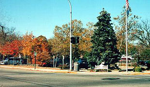
West side of street
This corner at the center of the Village of Clarkston became the site of the municipal parking lot after a fire in 1958 damaged the Caribou Inn. The Caribou was the last name used for the inn which was built in 1872 as the Demerest House, Samuel Demerest, proprietor. The tax records of 1872 listed William Stoors for the property. Reportedly he was the proprietor. As ownership of the property changed every few years until 1920, so did the name of the inn. The names in order were the Demerest, the Clarkston House, the Nelson House, the Wooster, the New Wooster and finally the Caribou Inn. See the 2/1/1968 Clarkston News article regarding Clarkston inns by Constance Lektzian & the 7/1/1976 article by Maurice Cole.
There was a large stable to the west of the Demerest House, on the east shore of the Mill Pond. See circa 1890 photo, page 21, Heritage & the 1872 Map of the Village for the building footprints. A Pontiac Post newpaper item 9/04/1902 noted that "James F. Wooster is repairing the hotel barn for livery purposes." Wooster operated the inn at the time. The livery service was begun to deliver the tourists from the train station to the hotel. (Note that the properties on Block 18 & 24 which fronted on Main Street originally did not extend to the west all the way to the east edge of the Mill Pond.) An item in the 5/28/1903 issue of the Oakland County Post noted "Linabury Brothers have purchased the complete livery stock of J. F. Wooster making their livery now one of the most complete in the county."
In the winter Wooster sponsored horse races on the frozen Mill Pond according to reports in the Pontiac newspapers at the turn of the 20th century. Another newspaper item of 4/27/1905 noted that the "carpenters are at work on the hotel and the house will be remodelled all over both inside and out." A 1908 Map of the Village has the footprint of a large building and a small building "the house" apparently on the property Wooster owned at the time.
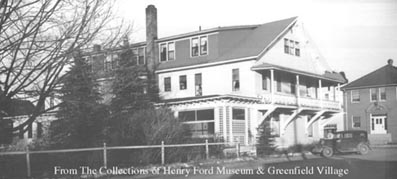
Old photos show the original building as a two story structure with a wraparound veranda style porch. Large dormers were added to the east and west side of the gable roof subsequently. The square bracketed porch supports were at some time replaced with large brackets supporting a cantilevered second story balcony. See photo, right, of the Caribou Inn, viewed from West Washington St.
Historically, since this was the center of the Village it is not surprising that there were wood buildings on this site early in Clarkston's history. Historically, according to an Oakland County Atlas, published in 1877, Albert Birdsell had the first blacksmith shop in Clarkston on this site in 1838. The 1860 tax rolls show David Hoyt as owner of the site with the notation "House old". Presently there is no specific information about either of these buildings. By 1862 J. M. Haight, a "manufacturer of tin, copper and sheet iron ware" owned a portion of the site.
Official Property Description:
- Lots 5 & 6 Block 18 of Nelson W. Clark's Original Plat of the Village in the Southwest 1/4 of Section 20 in Independence Township.
(Regarding Block 18: Nelson Washington Clark's original plat map shows 6 lots on this Block, each lot appears to be 100 feet wide, totaling 600'. The actual lots from Washington Street to the spillway add up to 333.5'. Block 18 originally included the outlot & part of the lot north.) - Lot 15 of the Supervisor's Replat of the Northwest Addition & Part of the Original Plat.
Significant Property History:
- Note: All the properties currently located in the Historic District were originally part of a tract registered by Butler Holcomb with the federal government on October 22, 1831. Thus, abstracts for these properties, when they exist, show the original transfer to be from the United States to Butler Holcomb and may also include references to then President Andrew Jackson.
- 1832 Butler Holcomb, the Northeast 1/4, the Southeast 1/4, the east 1/2 of the Northwest 1/4 and the east 1/2 of the Southwest 1/4 of Section 20.
- 1835 Butler Holcomb to Jeremiah, the south part of the east half of the Southwest 1/4 of Section 20.
- 1838 Reportedly the site of Albert Birdsell's blacksmith shop.
- 1839 Jeremiah Clark to Nelson W. Clark, one equal undivided half of the south part of the west 1/2 of the Southwest 1/4 of Section 20.
- 1842 Nelson W. Clark's Plat of the Village.
- 1843 N. W. & Phidelia A. Clark to Polly Clark, Lots 3, 4, 5 & 6 Block 18.
- 1844 Jeremiah Clark, Lots 5 & 6 Block 18, assessed value $200. Jeremiah Clark, Lot 4 Block 18, assessed value $5. Jeremiah Clark, Lot 3 Block 18, assessed value $5.
- 1846 Jeremiah Clark, Lots 3, 4, 5 & 6 Block 18, assessed value $200.
- 1847 Jeremiah Clark, Lots 3, 4, 5 & 6 Block 18, "occupied together", assessed value $200.
- 1848 Polly Clark, Lots 3, 4, 5 & 6 Block 18, assessed value $260.
- 1849 Polly Clark to Myron G. Cobb, Lots 3, 4, 5 & 6 Block 18, assessed value $245.
- 1857 David Hoyt, Lots 3, 4, 5 & 6, assessed value 4600.
- 1860 David Hoyt, Lots 3, 4, 5 & 6. "House old".
- 1862 David Hoyt, Lot 6 (3 & 4 also) , assessed value $450.
J. M. Haight, Lot 5, assessed value $250. - 1865 Wm. Vliet, the southeast 1/4 of Lot 6, assessed value $100.
J. M. Haight, Lot 5. - 1866 Wilson Vliet, the southeast 1/4 of Lot 6, assessed value $100.
T. H. Stewart, the northwest 3/4 of Lot 6, assessed value $60. - 1867 J. M. Haight, Lot 5, assessed value $250.
& the northwest 3/4 of Lot 6, assessed value $30. - 1868 J. M. Haight, Lot 5, assessed value $240.
Samuel Demerest, the northwest 3/4 of Lot 6 except 2 rods front & 5 rods back on the northeast corner.
S. Fisher of F. Stewart, Lot 6 in the northeast corner thereof, assessed value $30. - 1872 Map of the Village shows the building footprint of the Demerest House, proprietor William Stoors, Lots 5 & 6, assessed value $1200.
- 1880 George S. Swift, Lots 5 & 6, assessed value $4000.
- 1883 J., "Jesse", B. Sharpe, Lots 5 & 6, assessed value $4000.
- 1890 George H.Turk to George Vaughn.
- 1896 Map of the Village, labeled Clarkston House.
- 1899 W. Dwight DeNio, Lots 5 & 6 Block 18, assessed value $3000.
- 1906 James Wooster, Lots 5 & 6, assessed value $3800.
- 1908 Map of the Village has the footprint of a large building on Lot 6 and a small one on Lot 5.
- 1910 William Cheeseman, Lots 5 & 6, assessed value $4500.
- 1917 Goebel Brewery Co., Lots 5 & 6, assessed value $5000.
- 1919 as above.
- 1920 Wm., Mae & Nell Barry.
- 1921 W. J. Barry.
- 1925 William, Mae & Nellie Barry, Lots 5 & 6 "to the high water mark".
- 1927 Wm. J., Mae & Nellie Barry, Lots 5 & 6 & the public way to the Pond, assessed value $6000.
- 1930 as above, assessed value $7000.
- 1950 R. M. Parker & C. F. Hancock, Lot 15.
- 1954 as above.
- 1958 Ernie Felice.