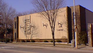
39 South Main St.

There were wooden buildings on this lot early in Clarkston's history. The building now seen on this site was built in the early 1970s.
The building which occupies this lot today was built in the early 1970s for office - rental use. Historically, this lot was a part of Clarkston's manufacturing/ commercial history. The value of this Lot as early as 1844 suggests that there was a building on the site by then, a part of Isaac Place's property north to Depot Road. Place was in business with a "Hirst" on that Lot by 1848. Perhaps this site was that of his house or a storehouse or a shop. This is no information about this early building or buildings. There is a footprint of a building on this site on the 1872 Map of the Village. It is likely that a Greek Revival style house, circa 1850, typical of many others in the area, with a one & 1/2 story, single story wing, configuration occupied this site until it was remodeled by Jasper Linabury about 1900. A Mansard Roof then capped the new home with three full stories on the rear, west elevation. This house burned in 1950. At the time it housed three families. Jasper Linabury had a furniture store (photos, Heritage, pg. 50 & pg. 55) on the site of 15 South Main. Tax records also listed him for property behind this site on the alley/Mill St. Linabury also had a barn/stable for his livery service on North Main Street (photo, Heritage, pg.55).
- Lot 2 Block 26 of Nelson W. Clark's Original Plat of the Village in the Southwest 1/4 of Section 20 of Independence Township
- Lot 72 of the Assessor's Plat.
- 1844 Isaac Place, Lot 2 Block 26, assessed value $100.
- 1846 Isaac Place, Lot 2 Block 26, assessed value $115.
- 1847 Isaac Place, Lot 2 Block 25, assessed value $110.
- 1848 Isaac Place, Lot 2 Block 26, assessed value $150.
- 1850 Eleazer James, east 1/2 Lots 1 & 2, assessed value $190.
- 1857 Taylor H. Stewart, west 1/2 of Lots 1 & 2, assessed value $750. (See entries for 31 S. Main)
- 1872 Map of the Village, L. Bingham, footprint of a building.
- 1881 Joel Hammond, Lot 2, assessed value $350, & 15' off the south side of Lot 1.
- 1889 O. A. Smith Lot 2, assessed value $500, & 15' off the south side of Lot 1.
- 1891 O. A. Smith, as above, & a piece north by the St., west by Abbey, east by Peter green & land of his own.
- 1895 Jasper Linabury, Lot 2 &15'...Block 26, assessed value $400.
- 1900 J. Linabury, as above, assessed value $500.
- 1903 as above, assessed value $600.
- 1909 S. L. Linabury, as above, assessed value $600.
- 1924 as above, assessed value $2200.
- 1925 as above.


