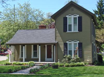
3 North Holcomb St.

This simple vernacular late Victorian farmhouse was apparently built for Washington C. Scranton, 1881-1883.
While 1979 research for this house listed circa 1850 as a probable date of construction, it would seem more likely the house was built by/for W.C. Scranton between 1881 and 1883. An 1872 map of the Village shows the owner as J. M. Clark who owned both Lots 8 and 9 in the Northwest Addition to Nelson W. Clark's Original Plat of the Village. This corresponds with 1863 tax record information which listed a value of $600, for the two lots, indicating a building of some kind somewhere on the site at the time. The footprint of a building may be seen on the 1872 map, but it is on Lot 8 and is 17 N. Holcomb not 3 N. Holcomb. In 1881 W. C. Scranton was shown for the south 1/2 of Lot 9, assessed value $400. The value jumped to $1,000 by 1883, certainly indicating major construction, probably this house. W. C. (Washington Clark) Scranton, owned property on the east side of North Main St. in the 1850s (see 42.52 & 58 N. Main). In 1895 a small store building, which according to the bill of sale was known as Washington Scranton's store, was moved from this lot to the southeast corner of South Main & East Washinton Streets. This building became the store of Daniel Addis, 2 S. Main. The late Victorian farmhouse style of the building and its tall slender proportions also seem to support the 1880s construction date. The only distinctive architectural detail, the pointed arch window hoods, seem to be inspired by the earlier Gothic Revival Style. The house can be seen in photos, pages 18 & 19, Heritage, a view from the rear, and page,56, from the south looking northeast.
- Lot 9 of the Northwest Addition to Nelson W. Clark's Original Plat of the Village in the Southwest 1/4 of Section 20 in Independence Township.
- Lot 3 of the Supervisor's Replat of the Northwest Addition and part of the Original Plat.
- Note: All the properties currently located in the Historic District were originally part of a tract registered by Butler Holcomb with the federal government on October 22, 1831. Thus, abstracts for these properties, when they exist, show the original transfer to be from the United States to Butler Holcomb and may also include references to then President Andrew Jackson.
- 1850 William Holcomb, the south 3/4 of the Northwest 1/4 of Section 20, assessed value $420. The Northwest 1/4, 40 acres, assessed value $75. The east 1/2 of the Southwest 1/4, 10 acres, assessed value $30. David S. Lewis, the northeast 1/4 of the Southwest 1/4
- 1860 John Derrick, Lots 8 & 9, and property to the west.
- 1861 John Derrick, Lots 8 & 9, and property to the west, assessed value $90.
- 1862 John Derrick, as above.
- 1863 J. M. Clark, Lots 9 & 8, assessed value $600.
- 1872 J. M. Clark, Lots 8 & 9, assessed value $600, and land to the west, assessed value $850.
- 1881 W. C. Scanton, the south 1/2 of Lot 9, assessed value $400.
- 1883 W. C. Scanton, the south 1/2 of Lot 9, assessed value $1000.
- 1889 W. C. Scanton, the south 1/2 of Lot 9, assessed value $1000. (William Kyle now owns property to the west).
- 1909 Carrie Barrett, the south 1/2 of Lot 9, assessed value $1000.
- 1914 Carrie Barrett, the south 1/2 of Lot 9, assessed value $1250.
- 1920 Mrs. William Kyle, Lot 9, assessed value $2000, and property to the west.
- 1929 Mrs. William Kyle, the south part of Lot 9, assessed value $1400.
- 1931 Carrie Kyle, Lots 2 and 3, assessed value $1700.
- 1943 Carrie Kyle, Lots 2 and 3, assessed value $1700.
- 1953 Leone K. Schuder (Det.) Lot 3, assessed value $2000. William Kyle had the property to the west.


