2 South Main St.

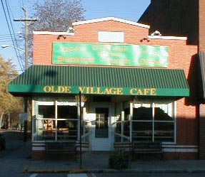
About 1924 owner, Leroy Addis applied yellow brick to the wooden building which his father, Daniel moved to this lot in 1895. The Addis soda shop/candy store occupied the building for many years.
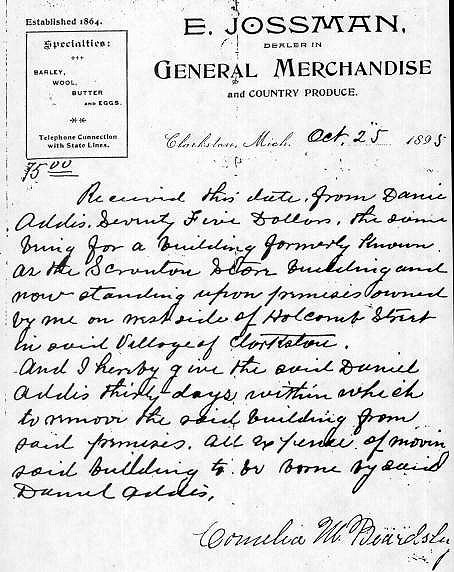
One of the area's earliest settlers, William Axford, owned this property in 1838. Axford was a Township Supervisor, 1849-1852 & 1854-1859. He and his brother, John, are credited with building the "first store at Clarkston". While this might be the site of that store, it is not clear since the Axford's were listed in 1850 tax records for a "store & dwelling" on Lots 5 & 6 of Block 1 which would put the store south of this location, about where part of the Clarkston Cafe is now. One of Clarkston's early manufacturer/craftsmen was listed in tax rolls for this site begining 1844 and the assessed value at the time was high enough to assume that there was a building on the site by then. The 1850 tax rolls listed Philip Foy as the owner of Lot 2, Block 1, except for 24 x 44 feet on the southwest corner which belonged to Horatio Foster. Foy and wife, Sarah, also owned the west 1/2 of Lot 1, Block 1, now a part of the property of 8 East Washington. Until 1856, the property on the corner of South Main Street and East Washington Street apparently held Foy's shop while his residence was the house at 8 E. Washington St. In 1840 Foy and Albert Birdsell, the first Village blacksmith, " formed a partnership to manufacture fanning mills and engage in general blacksmithing" in a new shop "near where Smith's (Nicholas B. Smith) store stands." (Heritage, pg.20). Smith's store was on the northeast corner of N. Main & E. Washington St. It is not known what became of Foy and Birdsell's building, but an 1895 bill of sale, below, for a building which was reportedly moved to this site makes it clear it is not the same one which served as the Addis candy/soda shop. The property which has recently served a variety of commercial uses was long known as the site of the Addis store, first owned by Daniel, then son, Roy. Daniel Addis is listed for the site beginning the turn of the century. There is an 1895 bill of sale from E. Jossman, dealer in general merchandise & produce and signed Cornelia M. Bearsley, showing the purchase by Daniel Addis of a building formerly known as the Scranton store. The store was on the site of the house at 3 North Holcomb St. According to family history, Daniel moved that building to the 2 S. Main Street site. Daniel, then son, LeRoy, "Roy", ran a candy store/soda shop on this site until the mid 1930s. About 1924 Roy bricked three sides of the building with a buff yellow colored brick, leaving the south facade's original clapboard exposed (this side was covered with aluminum siding in the 1970s). LeRoy, "Roy" and wife, Margaret Hammond Addis, lived at 44 E. Washington. In 1999 a new window was installed on the north facade after new owners changed the name of Carol's Village Grill to the Olde Village Grill. Architecturally, this is a simple false front building with a street facing pediment which rises above the actual roof height to give the facade more importance. Note the "Addis" nameplate.
- 20' of Lot 2 Block 1 of Nelson W. Clark's Original Plat of the Village in the Southeast 1/4 of Section 20 in Independence Township
- Lot 5 of the Assessor's Plat.
- 1838 Wm. Axford.
- 1844 Phillip Foy, Lot 2 Block 1, assessed value $220.
- 1846 Phillip Foy, Lot 2 Block 1, assessed value $175.
- 1847 Phillip Foy, Lot 2 Block 1, assessed value $200.
- 1848 Phillip Foy, Lot 2 Block 1, assessed value $215.
- 1848 Thomas and Loisa Chapple to John Derrick, the west 1/2 of Lot 1 Block 1. Then Derrick to Philip Foy, as above. (Horatio Foster had the south part of the west 1/2 of Lot 2 and road rights.)
- 1849 Phillip Foy, Lot 2 Block 1, except 24' x 44' in the southwest corner, assessed value $155, and the west 1/2 of Lot 1 Block 1, assessed value $16.
- 1850 Philip Foy, Lot 2 Block 1, except 24'x 44' in the southwest corner-sold to Horatio Foster (means southeast corner?), assessed value $290.
- 1867 Hill & Denniston, Lot 2 Block 1, except 24' x 40' back in the southeast. corner, assessed value $400.
- 1868 Samuel Demerest, west 1/2 of Lot 2, except 24' x 40' in s.e.corner.
- 1872 Map of the Village shows the owner, S. Demerest, and a building footprint , 20' x 70' of the northwest corner, Lot 2 Block 1, assessed value $400
- 1880 James Demerest.
- 1881 Leman W. Allen, 20' off the north side Lot 2 Block 1, assessed value $600.
- 1885 Peter Dow, as above.
- 1887 Peter Dow, as above.
- 1904 Addis, as above, assessed value $600.
- 1915 Daniel Addis, as above.
- 1932 as above.


