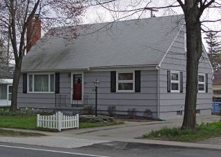
12 South Holcomb St.

East side of street
The ranch house which is on this site now was built about 1955. In 1982 a 12' x 22' 4" addition was constructed on the east facade. The aluminum siding which covered the house was removed and cedar shake siding was applied to the addition to match the original siding. Historically the 1872 Map of the Village has a footprint of a building on this lot at that time, owner Mrs. Catherine Bell. The assessed value of the building then was only $150 indicating either a small structure or one in poor condition. The value doubled by 1883 & then fluctuated until 1924. At present there is no more information available about this early structure.
Official Property Description:
- Lot 2 Block 15 of Nelson W. Clark's Original Plat of the Village in the Southwest 1/4 of Section 20 in Independence Township.
- Lot 2 Block 1 of Myron G. Cobb's Southwest Addition to the Original Plat of the Village.
- Lot 84 of the Assessor's Plat
Significant Property History:
- Note: All the properties currently located in the Historic District were originally part of a tract registered by Butler Holcomb with the federal government on October 22, 1831. Thus, abstracts for these properties, when they exist, show the original transfer to be from the United States to Butler Holcomb and may also include references to then President Andrew Jackson.
- 1842 Nelson W. Clark, Original Plat of the Village.
- 1843 N. W. & Phidelia Clark to Polly Clark, Blocks 13, 14, 15, & 16; Lots 3, 4, 5, & 6 Block 18.
- 1844 Nelson W. Clark, Block 15, assessed value $15.
- 1848 Polly Clark, Blocks 13, 14, 15, & 16, assessed value $76.
- 1854 Cobb's Plat of the Southwest Addition.
- 1855 William Brown, Lot 2 Block 1, assessed value $80.
- 1861 William Brown, as above, assessed value $100.
- 1864 Henry T. & Mary E. Hirst, Lot 2 Block 1 (& Lot 5 & the south 1/2 of Lot 4), assessed value $450.
- 1869 Joseph Tuper, Lot 2 Block 1, assessed value $140.
- 1872 Map of the Village has a building footprint on this site, owner Mrs. Catherine Bell. Lot 2 Block 1, assessed value $150.
- 1876 Mrs. Catherine Bell.
- 1876 Wm. S. Hoyt, Lot 2 Block 1, assessed value $100.
- 1878 as above, assessed value $150.
- 1880 as above, assessed value $250.
- 1883 as above, assessed value $300.
- 1888 Mrs. Margaret Scadding, Guardian, Lot 2 Block 1, assessed value $150.
- 1900 as above, assessed value $200.
- 1904 as above, assessed value $300.
- 1910 Hugh Green, assessed value $400.
- 1914 as above, assessed value $650.
- 1920 as above, assessed value $800.
- 1924 Walter H. Green, assessed value $700.
- 1935 as above, assessed value $300.
- 1937 as above, assessed value $300.
- 1940 Ford, Lot 84.
- 1950 Ford, Lot 84, assessed value $300.
- 1954 Glenn Sutphen.
- 1956 Henry M. Rankin
Historic District Commission Documents:


