![]()
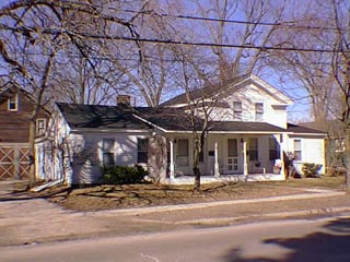
121-123 North Main St.
West side of street
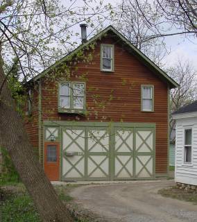
While the original section of this house was built about 1850, the garage dates from about 1920.
The original section of this house was built about 1850 as a simple Midwestern adaptation of the Greek Revival style. It was most likely the home of David S. Lewis whom records listed by 1847 for the taxes. His wife, Mary, inherited the property upon his death. She later married Eleazer Thurston. The 1872 Map of the Village has the footprint of a building on the north of the Thurston's land. Since then the house has seen a few changes. The front porch has the turned spindle supports of later Victorian style. While the house probably served as a single family residence it has long been used as a duplex. The two car garage at the rear was built by Earl Walter in the 1920s. He and his wife and daughters lived above the garage while he stored his trucks below. Walter had a trucking business. On Saturday he would gather the produce, especially potatoes, from the surrounding farms and deliver it to the Eastern Market in Detroit. In Detroit he filled orders from Clarkston merchants for goods for their stores.
Official Property Description:
- The northeast corner of the the Southwest 1/4 of Section 20 in Independence Township, not a part of Nelson W. Clark's Original Plat of the Village.
- Lot 39 of the Supervisor's Plat No. 1.
Significant Property History:
- 1832 Butler Holcomb, the east 1/2 of the southwest 1/4 of Section.
- 1844 Gamaliel Truesdell, the northeast 1/4 of the Southwest 1/4, assessed value $215.
- 1846 Joseph "Chatman", one acre on the northwest corner of the northeast 1/4 of the Southwest 1/4 of Section 20, assessed value $10.
- 1848 Joseph "Chapman", the northeast corner of the Southwest 1/4 of Section 20, assessed value $100.
- 1847 David Lewis.
- 1849 D. S. Lewis, the northeast corner of the Southwest 1/4, assessed value $103.
- 1860 Mrs. Eleazer Thurston.
- 1872 Map of the Village has a building footprint, owner, Mrs. Thurston. 2 & 1/2 acres, assessed value $700.
- 1895 "W. H." (H. W.) Lewis, assessed value $850.
- 1904 Mrs. C. Dunston, assessed value $1200.
- 1908 Mrs. Clarinda Dunston.
- 1910 John Dunston & Hill.
- 1915 John Dunston, assessed value $1500.
- 1918 David Miller.
- 1920 Earl Walter, assessed value $2000. Alvin Beardslee, 50' off the south side, east by Walter, assessed value $500.
- 1927 Earl Walter, assessed value $3500.
- 1954 Lloyd M. & Gladys Sibley, Lot 39. Lloyd Sibley, Lot 40.
Architecture Style:
Historic District Commission Documents: