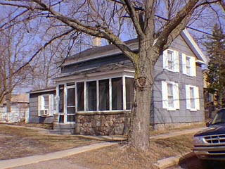
15 Church St.

15 and 21/30 E. Church were both part of the property of John Hertwig 1850-1860. The latter was apparently originally Hertwig's residence. John Hertwig/Herwig, a tailor who came to Clarkston in 1842, ran a tavern and inn at 22/24 S. Main for a time. See Heritage, pages 11 and 20. His wife, and heir, Margaret, became Mrs. Daniel Scadding by 1865. Mrs. Scadding held this property until after the turn of the century. This house became a separate piece by 1914, owner Fred Ellis. The small 1 & 1/2 story Greek Revival style building has the wide broken pediment entablature, low-pitched gable roof and symmetrically placed openings typical of the Midwestern adaptation of the style. The stone porch was added circa 1910 when much of the decorative stone work was done in the Village. Asbestos shingles cover the original clapboard. A kitchen at the rear of the house was remodeled in the 1980s. The garage is also new construction.
- The west part (70.5') of Lot 9 Block 1 of Nelson W. Clark's Original Plat of the Village in the Southeast 1/4 of Section 20 in Independence Township.
- Lot 43 of the Assessor's Plat.
- 1831 United States to Butler Holcomb.
- 1833 Butler Holcomb & wife, Mary To Roswell/Roosevelt Holcomb, the west 1/2 of the Southeast 1/4 of Section 20.
- 1833 Butler Holcomb & wife, Mary To Roswell/Roosevelt Holcomb, and wife, Elvine Holcomb, and Daniel B. Holcomb and wife, Alimira to Jeremiah Clark III, the south part of the west 1/2 of the Southeast 1/4 of Section 20.
- 1839 Jeremiah Clark III to Nelson Washington Clark, the undivided 1/2 of the west 1/2 of the Southeast 1/4 of Section 20 commencing.......
- 1842 Jeremiah Clark III & wife, Polly to Nelson W. Clark, the south part of the west 1/2 of the Southeast 1/4 of Section 20. Also other land.
- 1842 Jeremiah Clark III & Nelson W. Clark to Village of Clarkston (Original plat of the Village).
- 1850 John Hertwig, Lot 9 Block 1, (the tax record said " Block 26", but that was/is the site of 99 S. Main. The mistake was corrected in 1855.)
- 1855 John Hertwig, Lot 9 Block 1, assessed value $600.
- 1860 John Hertwig, Lot 9 Block 1, assessed value $500.
- 1861 Margaret Hertwig, (says Lot 2 Block 1, but this was corrected in 1869), assessed value $450.
- 1865 Margaret Hertwig, (says Lot 2 Block 1, but this was corrected in 1869), assessed value $450
- 1866 Margaret Scadding, Mrs. David Scadding . She also had the property south by William Daniels, west and north by the Plank Road.
- 1867 Margaret Scadding, assessed value $400.
- 1868 Margaret Scadding, assessed value $400.
- 1870 Margaret Scadding, assessed value $400.
- 1872 Map of the Village has a building footprint, owner D. Scadding, photo Heritage pg. 22.
- 1904 Mrs. Scadding, Lot 9 Block 1, assessed value $1000.
- 1914 Fred Ellis, the west 62' of Lot 9 Block 1.
- 1915 Fred Ellis, the west 62' of Lot 9 Block 1.
- 1926 Dennis Amzi, Lot 9 except 95', assessed value $1000.
- 1932 Dennis Amzi , the west 70' of Lot 9
- 1935 Dennis Amzi Estate, assessed value $700, Lot 9 Block 1, except the east 95' & 11.5' for an alley.
- 1954 Erwin A. Baker, Lot 43.
- 1956 Bertha Terry.
- 1970 Erwin Baker.


